


Google's 3D map
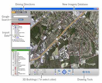

Yesterday the Internet search leader Google Inc. unveiled a new satellite
based three dimensional (3D) mapping product -- Google Earth. This free
service uses broadband streaming technology and 3D graphics to show an
aerial view of a user-requested location. The software can zoom in from
space-level close enough to see streets and buildings, and overlays the
search location on the picture. The view itself can be tilted and rotated.
The service includes local search for finding businesses, residences, points
of interest and other places. Driving instructions are also overlaid on the
aerial view, and are available in text format, which is printable.
The software for the service can be downloaded free from the search
giant's Web site. Google Earth is "much like a video game, enabling users
to interactively explore the world — either their own neighborhood or the
far corners of the globe," said Keyhole general manager in a statement.
"With many ways to access geographic information, Google provides a
very rich local search experience for users worldwide."
For an annual fee of only $20, you can also use Google Earth Plus, an
optional upgrade adding GPS device support, the ability to import
spreadsheets, drawing tools and better printing. And for professional and
commercial uses, for an annual subscription of $400, Google Earth Pro
provides the ultimate research, presentation and collaboration tool for
location information.
posted by Quark @ 7:03 AM
![]()
0 Comments:
Post a Comment
<< Home